
| |
Stonehenge | 
Custom Search
|
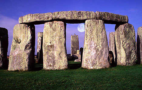
Stonehenge is a prehistoricmonument located in the English county of Wiltshire, about 3.2 kilometres (2.0 mi) west of Amesbury and 13 kilometres (8.1 mi) north of Salisbury. One of the most famous sites in the world, Stonehenge is composed of earthworks surrounding a circular setting of large standing stones. It is at the centre of the most dense complex of Neolithic and Bronze Age monuments in England, including several hundred burial mounds.
Archaeologists had believed that the iconic stone monument was erected around 2500 BC, as described in the chronology below. One recent theory, however, has suggested that the first stones were not erected until 2400-2200 BC,whilst another suggests that bluestones may have been erected at the site as early as 3000 BC (see phase 1 below). The surrounding circular earth bank and ditch, which constitute the earliest phase of the monument, have been dated to about 3100 BC. The site and its surroundings were added to the UNESCO's list of World Heritage Sites in 1986 in a co-listing with AveburyHenge monument. It is a national legally protected Scheduled Ancient Monument. Stonehenge is owned by the Crown and managed by English Heritage, while the surrounding land is owned by the National Trust.
Archaeological evidence found by the Stonehenge Riverside Project in 2008 indicates that Stonehenge served as a burial ground from its earliest beginnings. The dating of cremated remains found on the site indicate burials from as early as 3000 BC, when the initial ditch and bank were first dug. Burials continued at Stonehenge for at least another 500 years.

Contents
|
Etymology
The Oxford English Dictionary cites ¯lfric's 10th-century glossary, in which henge-cliff is given the meaning "precipice", a hanging or supported stone, thus the stanenges or Stanheng "not far from Salisbury" recorded by 11th-century writers are "supported stones". William Stukeley in 1740 notes, "Pendulous rocks are now called henges in Yorkshire...I doubt not, Stonehenge in Saxon signifies the hanging stones."[7] Christopher Chippindale's Stonehenge Complete gives the derivation of the name Stonehenge as coming from the Old English words stân meaning "stone", and either hencg meaning "hinge" (because the stone lintels hinge on the upright stones) or hen(c)en meaning "hang" or "gallows" or "instrument of torture". Like Stonehenge's trilithons, medieval gallows consisted of two uprights with a lintel joining them, rather than the inverted L-shape more familiar today.
The "henge" portion has given its name to a class of monuments known as henges.[7] Archaeologists define henges as earthworks consisting of a circular banked enclosure with an internal ditch.[8] As often happens in archaeological terminology, this is a holdover from antiquarian usage, and Stonehenge is not truly a henge site as its bank is inside its ditch. Despite being contemporary with true Neolithic henges and stone circles, Stonehenge is in many ways atypical - for example, at over 24 feet tall, its extant trilithons supporting lintels held in place with mortise and tenon joints, make it unique.[9][10]
History

Mike Parker Pearson, leader of the Stonehenge Riverside Project, noted that Stonehenge was associated with burial from the earliest period of its existence:
Stonehenge was a place of burial from its beginning to its zenith in the mid third millennium B.C. The cremation burial dating to Stonehenge's sarsen stones phase is likely just one of many from this later period of the monument's use and demonstrates that it was still very much a domain of the dead.[6]— Mike Parker Pearson
Stonehenge evolved in several construction phases spanning at least 1500 years. There is evidence of large-scale construction on and around the monument that perhaps extends the landscape's time frame to 6500 years.
Scholars believe that Stonehenge once stood as a magnificent complete monument. This cannot be proved as around half of the stones that should be present are missing, and many of the assumed stone sockets have never been found. Dating and understanding the various phases of activity is complicated by disturbance of the natural chalk by periglacial effects and animal burrowing, poor quality early excavation records, and a lack of accurate, scientifically verified dates. The modern phasing most generally agreed to by archaeologists is detailed below. Features mentioned in the text are numbered and shown on the plan, right.
Before the monument (8000 BC forward)
Archaeologists have found four, or possibly five, large Mesolithic postholes (one may have been a natural tree throw), which date to around 8000 BC, beneath the nearby modern tourist car-park. These held pine posts around 0.75 metres (2 ft 6 in) in diameter which were erected and eventually rotted in situ. Three of the posts (and possibly four) were in an east-west alignment which may have had ritual significance; no parallels are known from Britain at the time but similar sites have been found in Scandinavia. Salisbury Plain was then still wooded but four thousand years later, during the earlier Neolithic, people built a causewayed enclosure at Robin Hood's Ball and long barrow tombs in the surrounding landscape. In approximately 3500 BC, a large cursus monument was built 700 metres (2,300 ft) north of the site as the first farmers began to clear the trees and develop the area.
Stonehenge 1 (ca. 3100 BC)

The first monument consisted of a circular bank and ditch enclosure made of Late Cretaceous (Santonian Age) Seaford Chalk, (7 and 8), measuring about 110 metres (360 ft) in diameter, with a large entrance to the north east and a smaller one to the south (14). It stood in open grassland on a slightly sloping spot. The builders placed the bones of deer and oxen in the bottom of the ditch, as well as some worked flint tools. The bones were considerably older than the antler picks used to dig the ditch, and the people who buried them had looked after them for some time prior to burial. The ditch was continuous but had been dug in sections, like the ditches of the earlier causewayed enclosures in the area. The chalk dug from the ditch was piled up to form the bank. This first stage is dated to around 3100 BC, after which the ditch began to silt up naturally. Within the outer edge of the enclosed area was a circle of 56 pits, each about a metre (3'3") in diameter(13), known as the Aubrey holes after John Aubrey, the 17th-century antiquarian who was thought to have first identified them. The pits may have contained standing timbers creating a timber circle, although there is no excavated evidence of them. A recent excavation has suggested that the Aubrey Holes may have originally been used to erect a bluestone circle.[11] If this were the case, it would advance the earliest known stone structure at the monument by some 500 years. A small outer bank beyond the ditch could also date to this period.
Stonehenge 2 (ca. 3000 BC)
Evidence of the second phase is no longer visible. The number of postholes dating to the early 3rd millennium BC suggest that some form of timber structure was built within the enclosure during this period. Further standing timbers were placed at the northeast entrance, and a parallel alignment of posts ran inwards from the southern entrance. The postholes are smaller than the Aubrey Holes, being only around 0.4 metres (16 in) in diameter, and are much less regularly spaced. The bank was purposely reduced in height and the ditch continued to silt up. At least twenty-five of the Aubrey Holes are known to have contained later, intrusive, cremation burials dating to the two centuries after the monument's inception. It seems that whatever the holes' initial function, it changed to become a funerary one during Phase 2. Thirty further cremations were placed in the enclosure's ditch and at other points within the monument, mostly in the eastern half. Stonehenge is therefore interpreted as functioning as an enclosed cremation cemetery at this time, the earliest known cremation cemetery in the British Isles. Fragments of unburnt human bone have also been found in the ditch-fill. Dating evidence is provided by the late Neolithic grooved ware pottery that has been found in connection with the features from this phase.
Stonehenge 3 I (ca. 2600 BC)

Archaeological excavation has indicated that around 2600 BC, the builders abandoned timber in favour of stone, and dug two concentric arrays of holes (the Q and R Holes) in the centre of the site. These stone sockets are only partly known (hence on present evidence are sometimes described as forming ‘crescents’); however, they could be the remains of a double ring. Again, there is little firm dating evidence for this phase. The holes held up to 80 standing stones (shown blue on the plan), only 43 of which can be traced today. The bluestones (some of which are made of dolerite, an igneous rock), were thought for much of the 20th century to have been transported by humans from the Preseli Hills, 250 kilometres (160 mi) away in modern-day Pembrokeshire in Wales. Another theory that has recently gained support, is that they were brought much nearer to the site as glacial erratics by the Irish Sea Glacier.[12] Other standing stones may well have been small sarsens, used later as lintels. The stones, which weighed about four tons, consisted mostly of spotted Ordovician dolerite but included examples of rhyolite, tuff and volcanic and calcareous ash; in total around 20 different rock types are represented. Each monolith measures around 2 metres (6.6 ft) in height, between 1 m and 1.5 m (3.3-4.9 ft) wide and around 0.8 metres (2.6 ft) thick. What was to become known as the Altar Stone (1), is almost certainly derived from either Carmarthenshire or the Brecon Beacons and may have stood as a single large monolith.

The north-eastern entrance was widened at this time, with the result that it precisely matched the direction of the midsummer sunrise and midwinter sunset of the period. This phase of the monument was abandoned unfinished, however; the small standing stones were apparently removed and the Q and R holes purposefully backfilled. Even so, the monument appears to have eclipsed the site at Avebury in importance towards the end of this phase.
The Heelstone (5), a Tertiary sandstone, may also have been erected outside the north-eastern entrance during this period. It cannot be accurately dated and may have been installed at any time during phase 3. At first it was accompanied by a second stone, which is no longer visible. Two, or possibly three, large portal stones were set up just inside the north-eastern entrance, of which only one, the fallen Slaughter Stone (4), 4.9 metres (16 ft) long, now remains. Other features, loosely dated to phase 3, include the four Station Stones (6), two of which stood atop mounds (2 and 3). The mounds are known as "barrows" although they do not contain burials. Stonehenge Avenue, (10), a parallel pair of ditches and banks leading 3 kilometres (1.9 mi) to the River Avon, was also added. Two ditches similar to Heelstone Ditch circling the Heelstone (which was by then reduced to a single monolith) were later dug around the Station Stones.
Stonehenge 3 II (2600 BC to 2400 BC)
During the next major phase of activity, 30 enormous Oligocene-Miocene sarsen stones (shown grey on the plan) were brought to the site. They may have come from a quarry, around 40 kilometres (25 mi) north of Stonehenge on the Marlborough Downs, or they may have been collected from a "litter" of sarsens on the chalk downs, closer to hand. The stones were dressed and fashioned with mortise and tenon joints before 30 were erected as a 33 metres (108 ft) diameter circle of standing stones, with a ring of 30 lintel stones resting on top. The lintels were fitted to one another using another woodworking method, the tongue and groove joint. Each standing stone was around 4.1 metres (13 ft) high, 2.1 metres (6 ft 11 in) wide and weighed around 25 tons. Each had clearly been worked with the final visual effect in mind; the orthostats widen slightly towards the top in order that their perspective remains constant when viewed from the ground, while the lintel stones curve slightly to continue the circular appearance of the earlier monument. The inward-facing surfaces of the stones are smoother and more finely worked than the outer surfaces. The average thickness of the stones is 1.1 metres (3 ft 7 in) and the average distance between them is 1 metre (3 ft 3 in). A total of 74 stones would have been needed to complete the circle (59 stones) and the trilithon horseshoe (15 stones). Unless some of the sarsens have since been removed from the site, the ring appears to have been left incomplete. The lintel stones are each around 3.2 metres (10 ft), 1 metre (3 ft 3 in) wide and 0.8 metres (2 ft 7 in) thick. The tops of the lintels are 4.9 metres (16 ft) above the ground.
Within this circle stood five trilithons of dressed sarsen stone arranged in a horseshoe shape 13.7 metres (45 ft) across with its open end facing north east. These huge stones, ten uprights and five lintels, weigh up to 50 tons each. They were linked using complex jointing. They are arranged symmetrically. The smallest pair of trilithons were around 6 metres (20 ft) tall, the next pair a little higher and the largest, single trilithon in the south west corner would have been 7.3 metres (24 ft) tall. Only one upright from the Great Trilithon still stands, of which 6.7 metres (22 ft) is visible and a further 2.4 metres (7 ft 10 in) is below ground.

The images of a 'dagger' and 14 'axeheads' have been carved on one of the sarsens, known as stone 53 and further carvings of axeheads have been seen on the outer faces of stones 3, 4, and 5. The carvings are difficult to date, but are morphologically similar to late Bronze Age weapons; recent laser scanning work on the carvings supports this interpretation. The pair of trilithons in the north east are smallest, measuring around 6 metres (20 ft) in height; the largest, which is in the south west of the horseshoe, is almost 7.5 metres (25 ft) tall.
This ambitious phase has been radiocarbon dated to between 2600 and 2400 BC,[13] slightly earlier than the Stonehenge Archer, discovered in the outer ditch of the monument in 1978, and the two sets of burials, known as the Amesbury Archer and the Boscombe Bowmen, discovered 4.8 kilometres (3.0 mi) to the west. At about the same time, a large timber circle and a second avenue were constructed 3.2 kilometres (2.0 mi) away at Durrington Walls overlooking the River Avon. The timber circle was orientated towards the rising sun on the midwinter solstice, opposing the solar alignments at Stonehenge, whilst the avenue was aligned with the setting sun on the summer solstice and led from the river to the timber circle. Evidence of huge fires on the banks of the Avon between the two avenues also suggests that both circles were linked, and they were perhaps used as a procession route on the longest and shortest days of the year. Parker Pearson speculates that the wooden circle at Durrington Walls was the centre of a 'land of the living', whilst the stone circle represented a 'land of the dead', with the Avon serving as a journey between the two.[14]
Stonehenge 3 III
Later in the Bronze Age, although the exact details of activities during this period are still unclear, the bluestones appear to have been re-erected. They were placed within the outer sarsen circle and may have been trimmed in some way. Like the sarsens, a few have timber-working style cuts in them suggesting that, during this phase, they may have been linked with lintels and were part of a larger structure.
Stonehenge 3 IV (2280 BC to 1930 BC)
This phase saw further rearrangement of the bluestones. They were arranged in a circle between the two rings of sarsens and in an oval at the centre of the inner ring. Some archaeologists argue that some of these bluestones were from a second group brought from Wales. All the stones formed well-spaced uprights without any of the linking lintels inferred in Stonehenge 3 III. The Altar Stone may have been moved within the oval at this time and re-erected vertically. Although this would seem the most impressive phase of work, Stonehenge 3 IV was rather shabbily built compared to its immediate predecessors, as the newly re-installed bluestones were not well-founded and began to fall over. However, only minor changes were made after this phase.
Stonehenge 3 V (2280 BC to 1930 BC)
Soon afterwards, the north eastern section of the Phase 3 IV bluestone circle was removed, creating a horseshoe-shaped setting (the Bluestone Horseshoe) which mirrored the shape of the central sarsen Trilithons. This phase is contemporary with the Seahenge site in Norfolk.
After the monument (1600 BC on)
The last known construction at Stonehenge was about 1600 BC (see 'Y and Z Holes' below), and the last usage of it was probably during the Iron Age. Roman coins and medieval artefacts have all been found in or around the monument but it is unknown if the monument was in continuous use throughout prehistory and beyond, or exactly how it would have been used. Notable is the late 7th-6th century BC large arcing Scroll Trench which deepens E-NE towards Heelstone, and the massive Iron Age hillfort Vespasian's Camp built alongside the Avenue near the Avon. A decapitated 7th century Saxon man was excavated from Stonehenge in 1923.[15] The site was known to scholars during the Middle Ages and since then it has been studied and adopted by numerous different groups.
16th century to present
Stonehenge has changed ownership several times since King Henry VIII acquired Amesbury Abbey and its surrounding lands. In 1540 Henry gave the estate to the Earl of Hertford. It subsequently passed to Lord Carleton and then the Marquis of Queensbury. The Antrobus family of Cheshire bought the estate in 1824. During World War I an aerodrome had been built on the downs just to the west of the circle and, in the dry valley at Stonehenge Bottom, a main road junction had been built, along with several cottages and a cafe. The Antrobus family sold the site after their last heir was killed serving in France during the First World War. The auction by Knight Frank & Rutley estate agents in Salisbury was held on 21 September 1915 and included "Lot 15. Stonehenge with about 30 acres, 2 rods, 37 perches of adjoining downland." [c. 12.4365 ha][16] Cecil Chubb bought the site for £6,600 and gave it to the nation three years later. Although it has been speculated that he purchased it at the suggestion of — or even as a present for — his wife, in fact he bought it on a whim as he believed a local man should be the new owner.[citation needed]
In the late 1920s a nation-wide appeal was launched to save Stonehenge from the encroachment of the modern buildings that had begun to appear around it.[17] By 1928 the land around the monument had been purchased with the appeal donations, and given to the National Trust in order to preserve it. The buildings were removed (although the roads were not), and the land returned to agriculture. More recently the land has been part of a grassland reversion scheme, returning the surrounding fields to native chalk grassland.
In 2002 a public poll voted Stonehenge as one of the Seven Wonders of Britain, alongside Big Ben, the Eden Project, Hadrian's Wall, the London Eye, Windsor Castle, and York Minster.
Neopaganism
Stonehenge is a place of pilgrimage for neo-druids, and for certain others following pagan or neo-pagan beliefs. The midsummer sunrise began attracting modern visitors in the 1870s, with the first record of recreated Druidic practices dating to 1905 when the Ancient Order of Druids enacted a ceremony. Despite efforts by archaeologists and historians to stress the differences between the Iron Age Druidic religion and the much older monument, Stonehenge has become increasingly, almost inextricably, associated with British Druidism, Neopaganism and New Age philosophy. Between 1972 and 1984, Stonehenge was the site of a free festival. After the Battle of the Beanfield in 1985 this use of the site was stopped for several years, and currently ritual use of Stonehenge is carefully controlled.
Setting and access
As motorised traffic increased, the setting of the monument began to be affected by the proximity of the two roads on either side — the A344 to Shrewton on the north side, and the A303 to Winterbourne Stoke to the south. Plans to upgrade the A303 and close the A344 to restore the vista from the stones have been considered since the monument became a World Heritage Site. However, the controversy surrounding expensive re-routing of the roads have led to the scheme being cancelled on multiple occasions. On 6 December 2007 it was announced that extensive plans to build a tunnel under the landscape and create a permanent visitors' centre had been cancelled.[18] On 13 May 2009 the government gave approval for a £25 million scheme to create a smaller visitors' centre and close the A344, although this was dependent on funding and local authority planning consent.[19] On 20 January 2010 Wiltshire Council granted planning permission for a centre 2.5 km (1.6 miles) to the west and English Heritage confirmed that funds to build it would be available. Approval is still needed for the closure of the A344 and two nearby byways, which are popular with off-road enthusiasts and whose objections may yet jeopardise the scheme.[20]
When Stonehenge was first opened to the public it was possible to walk amongst and even climb on the stones, but the stones were roped off in 1977 as a result of serious erosion.[21] Visitors are no longer permitted to touch the stones, but are able to walk around the monument from a short distance away. English Heritage does, however, permit access during the summer and winter solstice, and the spring and autumn equinox. Additionally, visitors can make special bookings to access the stones throughout the year.[22]
The current access situation and the proximity of the two roads has drawn widespread criticism, highlighted by a 2006 National Geographic survey. In the survey of conditions at 94 leading World Heritage Sites, 400 conservation and tourism experts ranked Stonehenge 75th in the list of destinations, declaring it to be "in moderate trouble".[23]
Function and construction
Stonehenge was produced by a culture that left no written records. Many aspects of Stonehenge remain subject to debate. This multiplicity of theories, some of them very colourful, is often called the "mystery of Stonehenge".
There is little or no direct evidence for the construction techniques used by the Stonehenge builders. Over the years, various authors have suggested that supernatural or anachronistic methods were used, usually asserting that the stones were impossible to move otherwise. However, conventional techniques using Neolithic technology have been demonstrably effective at moving and placing stones of a similar size.[24] Proposed functions for the site include usage as an astronomical observatory, or as a religious site. Other theories have advanced supernatural or symbolic explanations for the construction.
More recently two major new theories have been proposed. Professor Mike Parker Pearson, head of the Stonehenge Riverside Project, has suggested that Stonehenge was part of a ritual landscape and was joined to Durrington Walls by their corresponding avenues and the River Avon. He suggests that the area around Durrington Walls Henge was a place of the living, whilst Stonehenge was a domain of the dead. A journey along the Avon to reach Stonehenge was part of a ritual passage from life to death, to celebrate past ancestors and the recently deceased.[14] On the other hand, Geoffery Wainwright, president of the Society of Antiquaries of London, and Timothy Darvill of Bournemouth University have suggested that Stonehenge was a place of healing – the primeval equivalent of Lourdes.[25] They argue that this accounts for the high number of burials in the area and for the evidence of trauma deformity in some of the graves. However they do concede that the site was probably multifunctional and used for ancestor worship as well.[26]
Folklore

"Heel Stone," "Friar’s Heel" or "Sun-Stone"
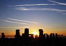
The Heel Stone lies just outside the main entrance to the henge, next to the present A344 road. It is a rough stone, 16 feet above ground, leaning inwards towards the stone circle. It has been known by many names in the past, including "Friar's Heel" and "Sun-stone". Today it is uniformly referred to as the Heel Stone or Heelstone. When one stands within Stonehenge, facing north-east through the entrance towards the heel stone, one sees the sun rise above the stone at summer solstice.
A folk tale, which cannot be dated earlier than the seventeenth century, relates the origin of the Friar's Heel reference.
- The Devil bought the stones from a woman in Ireland, wrapped them up, and brought them to Salisbury plain. One of the stones fell into the Avon, the rest were carried to the plain. The Devil then cried out, "No-one will ever find out how these stones came here!" A friar replied, "That’s what you think!," whereupon the Devil threw one of the stones at him and struck him on the heel. The stone stuck in the ground and is still there.
Some claim "Friar's Heel" is a corruption of "Freyja's He-ol" from the Nordic goddess Freyja and the Welsh word for track. The Heel Stone lies beside the end portion of Stonehenge Avenue.
A more simple explanation for the name might be that the stone heels, or leans.
The name is not unique; there was a monolith with the same name recorded in the 19th century by antiquarian Charles Warne at Long Bredy in Dorset.[27]
Arthurian legend
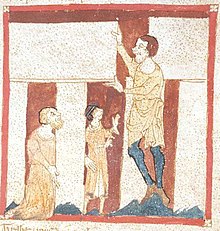
In the 12th century, Geoffrey of Monmouth included a fanciful story in his work Historia Regum Britanniae that attributed the monument's construction to Merlin.[28] Geoffrey's story spread widely, appearing in more and less elaborate form in adaptations of his work such as Wace's Norman French Roman de Brut, Layamon's Middle English Brut, and the Welsh Brut y Brenhinedd. According to Geoffrey, Merlin directed its removal from Ireland, where it had been constructed on Mount Killaraus by Giants, who brought the stones from Africa. After it had been rebuilt near Amesbury, Geoffrey further narrates how first Ambrosius Aurelianus, then Uther Pendragon, and finally Constantine III, were buried inside the ring of stones. In many places in his Historia Regum Britanniae Geoffrey mixes British legend and his own imagination; it is intriguing that he connects Ambrosius Aurelianus with this prehistoric monument as there is place-name evidence to connect Ambrosius with nearby Amesbury.
According to Geoffrey of Monmouth, the rocks of Stonehenge were healing rocks, called the Giant's dance, which giants brought from Africa to Ireland for their healing properties. Aurelius Ambrosias (5th century), wishing to erect a memorial to the 3,000 nobles, who had died in battle with the Saxons and were buried at Salisbury, chose Stonehenge (at Merlin's advice) to be their monument. So the King sent Merlin, Uther Pendragon (Arthur's father), and 15,000 knights to Ireland to retrieve the rocks. They slew 7,000 Irish but, as the knights tried to move the rocks with ropes and force, they failed. Then Merlin, using "gear" and skill, easily dismantled the stones and sent them over to Britain, where Stonehenge was dedicated. Shortly after, Aurelius died and was buried within the Stonehenge monument, or "The Giants' Ring of Stonehenge".
In another legend of Saxons and Britons, in 472 the invading king Hengist invited British warriors to a feast, but treacherously ordered his men to draw their weapons from concealment and fall upon the guests, killing 420 of them. Hengist erected the stone monument—Stonehenge—on the site to show his remorse for the deed.[29]
Archaeological research and restoration


Throughout recorded history Stonehenge and its surrounding monuments have attracted attention from antiquarians and archaeologists. John Aubrey was one of the first to examine the site with a scientific eye in 1666, and recorded in his plan of the monument the pits that now bear his name. William Stukeley continued Aubrey’s work in the early 18th century, but took an interest in the surrounding monuments as well, identifying (somewhat incorrectly) the Cursus and the Avenue. He also began the excavation of many of the barrows in the area, and it was his interpretation of the landscape that associated it with the Druids[30] Stukeley was so fascinated with Druids that he originally named Disc Barrows as Druids' Barrows. The most accurate early plan of Stonehenge was that made by Bath architect John Wood in 1740.[31] His original annotated survey has recently been computer redrawn and published.[32] Importantly Wood’s plan was made before the collapse of the southwest Trilithon, which fell in 1797 and was restored in 1958.
William Cunnington was the next to tackle the area in the early 19th century. He excavated some 24 barrows before digging in and around the stones and discovered charred wood, animal bones, pottery and urns. He also identified the hole in which the Slaughter Stone once stood. At the same time Richard Colt Hoare began his activities, excavating some 379 barrows on Salisbury Plain before working with Cunnington and William Coxe on some 200 in the area around the Stones. To alert future diggers to their work they were careful to leave initialled metal tokens in each barrow they opened.
In 1877 Charles Darwin dabbled in archaeology at the stones, experimenting with the rate at which remains sink into the earth for his book The Formation of Vegetable Mould Through the Action of Worms.
William Gowland oversaw the first major restoration of the monument in 1901 which involved the straightening and concrete setting of sarsen stone number 56 which was in danger of falling. In straightening the stone he moved it about half a metre from its original position.[32] Gowland also took the opportunity to further excavate the monument in what was the most scientific dig to date, revealing more about the erection of the stones than the previous 100 years of work had done. During the 1920 restoration William Hawley, who had excavated nearby Old Sarum, excavated the base of six stones and the outer ditch. He also located a bottle of port in the slaughter stone socket left by Cunnington, helped to rediscover Aubrey's pits inside the bank and located the concentric circular holes outside the Sarsen Circle called the Y and Z Holes.[33] Richard Atkinson, Stuart Piggott and John F. S. Stone re-excavated much of Hawley's work in the 40s and 50s, and discovered the carved axes and daggers on the Sarsen Stones. Atkinson's work was instrumental in understanding the three major phases of the monument's construction.
In 1958 the stones were restored again, when three of the standing sarsens were re-erected and set in concrete bases. The last restoration was carried out in 1963 after stone 23 of the Sarsen Circle fell over. It was again re-erected, and the opportunity was taken to concrete three more stones. Later archaeologists, including Christopher Chippindale of the Museum of Archaeology and Anthropology, University of Cambridge and Brian Edwards of the University of the West of England campaigned to give the public more knowledge of the various restorations and in 2004 English Heritage included pictures of the works in progress in its new book Stonehenge: A History in Photographs.[34][35][36]
In 1966 and 1967, in advance of a new car park being built at the site, the area of land immediately northwest of the stones was excavated by Faith and Lance Vatcher. They discovered the Mesolithic postholes dating from between 7,000 and 8,000 BC, as well as a 10m length of a palisade ditch – a V cut ditch into which timber posts had been inserted that remained there until they rotted away. Subsequent aerial archaeology suggests that this ditch runs from the west to the north of Stonehenge, near the avenue.[37]
Excavations were once again carried out in 1978 by Atkinson and John Evans during which they discovered the remains of the Stonehenge Archer in the outer ditch,[38] and in 1979 rescue archaeology was needed alongside the Heel Stone after a cable-laying ditch was mistakenly dug on the roadside, revealing a new stone hole next to the Heel Stone.
In the early 1980s Julian Richards led the Stonehenge Environs Project, a detailed study of the surrounding landscape. The project was able to successfully date such features as the Lesser Cursus, Coneybury henge and several other smaller features.
More recent excavations include a series of digs held between 2003 and 2008, led by Mike Parker Pearson, known as the Stonehenge Riverside Project. This project mainly investigated other monuments in the landscape and their relationship with the stones — notably Durrington Walls, where another ‘Avenue’ leading to the River Avon was discovered. In April 2008 Professor Tim Darvill of the University of Bournemouth and Professor Geoff Wainwright of the Society of Antiquaries, began another dig inside the Stone circle to retrieve dateable fragments of the original bluestone pillars. They were able to date the erection of some bluestones to 2300BC,[2] although this may not reflect the earliest erection of stones at Stonehenge. They also discovered organic material from 7000 BC, which, along with the Mesolithic postholes, adds support for the site having been in use at least 4000 years before Stonehenge was started. In August and September 2008, as part of the Riverside Project Julian Richards and Mike Pitts excavated Aubrey Hole 7, removing the cremated remains from several Aubrey Holes that had been excavated by Hawley in the 1920s, and re-interred in 1935.[39] A licence for the removal of human remains at Stonehenge had been granted by the Ministry of Justice (United Kingdom) in May 2008, in accordance with the Statement on burial law and archaeology issued in May 2008. One of the conditions of the licence was that the remains should be reinterred within two years and that in the intervening period they should be kept safely, privately and decently.[40][41]
A new landscape investigation was conducted in April 2009. A shallow mound, rising to about 40 cm (16 inches) was identified between stones 54 (inner circle) and 10 (outer circle), clearly separated from the natural slope. It has not been dated but speculation that it represents careless backfilling following earlier excavations seems disproved by its representation in 18th and 19th century illustrations. Indeed, there is some evidence that, as an uncommon geological feature, it could have been deliberately incorporated into the monument at the outset.[42] A circular, shallow bank, little more than 10 cm (4 inches) high, was found between the Y and Z hole circles, with a further bank lying inside the "Z" circle. These are interpreted as the spread of spoil from the original Y and Z holes, or more speculatively as hedge banks from vegetation deliberately planted to screen the activities within.[42]
Where is Stonehenge located ?
Amesbury, Salisbury, Wiltshire
Spring
16 Mar to 31 May
09.30 - 18.00
Summer
1 Jun to 31 Aug
09.00 - 19.00
Autumn
1 Sept to 15 Oct
09.30 - 18.00
Winter
16 Oct to 15 Mar
09.30 - 16.00
10.00 - 16.00
Child (5 - 15) £3.30
Child (Under 5)
Concession
(student, over 60) Free
£5.60
Family Ticket
(2 adults + up to 3 children) £16.50
| Tandoori Nights: Best Indian in Amesbury
| |||
|
 Tandoori Nights by puerto_loverLeave a Comment
Add to Your Trip Planner | Post a Question | Write a Tip |
| various: Snacks
| |||
|
 by Sjalen A sort of huge cheese scone with a peppery twang to it :) Leave a Comment
Add to Your Trip Planner | Post a Question | Write a Tip |
| By road By train By bus |
Useful telephone numbers
British Rail's Information line:
08457 48 49 50
www.thetrainline.com
National Express link
08705 80 80 80 (10p per min) www.nationalexpress.com
Local buses to Stonehenge
www.wdbus.co.uk/
The Post Code is:
SP4 7DE
By road
From Amesbury
2 miles west on the junction of A303 and A344/360
From London Gatwick Airport
Take the M23 motorway and join the M25 motorway, following the signs for Heathrow Airport.
From the M25, exit at junction 12 for the M3 motorway towards Basingstoke.
Once on the M3 follow it to junction 8 signed A303 Andover.
Continue on the A303 ALL the way until you reach a roundabout.
Go straight over this and 2 miles on bear right onto the A344 and the car park is on the right hand side about 500 metres on.
From London Heathrow Airport
Follow signs to the M4 West.
Continue for about 2 miles and come off at junction 4b onto the M25 South bound.
Follow the signs for Gatwick Airport. From the M25, exit at junction 12 for the M3 motorway towards Basingstoke.
Then follow the directions as above.
top of page
By train
The nearest train station to Stonehenge is Salisbury about 9.5 miles away.
From London the trains depart from Waterloo Station to Salisbury.
Check for times and prices as these may be subject to change and the trains depart approximately every hour. The journey takes about an hour and a half. Local buses or a cab can take you on.
top of page
By bus
The buses depart from Heathrow Airport and from Victoria Coach Station in the centre of London. The journey takes about 2 hours.
Get off at Amesbury.
From there you can either walk (about 2 miles), catch a local bus, or get a taxi.
You can buy tickets on the coach, at the coach station, or from ticket agents for National Express. It is the cheapest way to travel to Stonehenge.
If you are coming from Gatwick Airport you will need to first get to Heathrow Airport or to Victoria coach station (you can do this by bus) and from there change buses to Amesbury.
top of page
Contactdetails of Stonehenge
-----------------------------
http://www.english-heritage.org.uk/server/show/nav.20654
References
Keywords